


Aqua Map provides to the user an amazingly clear Nautical Chart using the full power of the modern displays, with intuitive and realistic symbols and colors.
Here below you have the complete list of symbols (and their meaning) you can find in the Aqua Map charts.
NOTE: this symbol are used to draw vector charts, in case of raster charts we display the symbols as present on the original chart.
Buoys & Beacons (Lateral)
Click here to see the IALA (International Association Lighthouses Authorities) System for more information about the Lateral Marks Maritime Buoyage System.
Green Lateral mark buoy (CAN)
IALA "A" : Starboard hand marks with conical topmark (if any).
IALA "B" : Port hand marks with cylindrical topmark (if any).
Red Lateral mark buoy (NUN)
IALA "A" : Port hand marks with cylindrical topmark (if any).
IALA "B" : Starboard hand marks with conical topmark (if any).
Bifurcation mark buoy
![]()
![]()
![]()
![]()
![]()
![]()
![]()
![]()
This mark indicates that a "preferred" channel (often, a deep channel suitable for heavy commercial traffic) lies to one side, and a secondary channel on the other. Vessels wishing to use the preferred channel observe the top colour of the mark, and vessels wishing to use the secondary channel observe the bottom colour.
Green Lateral mark beacon
![]()
IALA "A" : Starboard hand marks with conical topmark (if any).
IALA "B" : Port hand marks with cylindrical topmark (if any).
Red Lateral mark beacon
![]()
IALA "A" : Port hand marks with cylindrical topmark (if any).
IALA "B" : Starboard hand marks with conical topmark (if any).
Bifurcation mark beacon
![]()
![]()
![]()
![]()
This mark indicates that a "preferred" channel (often, a deep channel suitable for heavy commercial traffic) lies to one side, and a secondary channel on the other. Vessels wishing to use the preferred channel observe the top colour of the mark, and vessels wishing to use the secondary channel observe the bottom colour.
IALA System
Remember: Lateral marks have opposite meaning in different areas of the world (IALA system), see below images.
![]()
![]()
The world has been subdivided in two IALA areas:
IALA "A" : Europe, Africa, Australia, New Zealand and most of Asia except for Japan-Koreas-Philippines
![]()
IALA "B" : Americas and Japan-Koreas-Philippine
![]()
Buoys & Beacons (Cardinal)
- North cardinal mark:


- South cardinal mark:


- West cardinal mark:


- East cardinal mark:


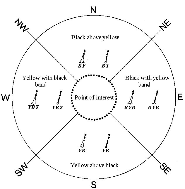
Cardinal Marks IALA System
Cardinal marks indicate the direction of safety as a cardinal (compass) direction (north, east, south or west) relative to the mark.
A cardinal mark indicates one of the four compass directions by:
- the direction of its two conical top-marks, which can both point up, indicating north; down, indicating south; towards each other, indicating west; or away from each other, indicating east;
- its distinctive pattern of black and yellow stripes, which follows the orientation of the cones - the black stripe is in the position pointed to by the cones (e.g. at the top for a north cardinal, in the middle for a west cardinal);
- optionally, its distinctive sequence of flashing light, which consists of a sequence of quick or very quick flashes whose number gives the clockface position which corresponds to the direction of the cardinal (e.g. three for an east cardinal, nine for a west; north has continuous flashes, and south may be augmented with a long flash, to help distinguish it from a west in difficult conditions)
A cardinal mark may be used to accomplish the following:
- Indicate that the deepest water is an area on the named side of the mark.
- Indicate the safe side on which to pass a danger.
- Draw attention to a feature in a channel, such as a bend, junction, branch, or end of a shoal.
- Draw attention to a new danger such as a grounded ship. In such cases two equal marks are often placed together to indicate that it's a newly marked danger and is not yet printed in official charts.
Other Buoys and Beacons
- Buoy Isolated Danger:


- Buoy Safe Water:


- Buoy Special Purpose:


- Buoy Installation:

- Mooring Buoy:

Lights
- Light or Lighted Structure (Single color):


- Multi Lights:

- Flood Light:

- Strip Light:

- Light Vessel:

- Fog signal (Bell, Horn, Whistle, Gong, Explosive, Diaphone, Siren, Reed, Typhon ...):

Dangers
Rocks
- Emerged Rock:

- Submerged Rock:

- Dangerous Rock:

Wrecks
- Emerged Wreck:

- Submerged Wreck:

- Dangerous Wreck:

Others
- Bottom Obstruction:

- Cables (if single cable a line, if an area as boundary):
Restricted and regulated areas
- Anchoring Prohibited:

- Diving Prohibited:

- Entry Prohibited:

- Entry Restricted:

- Fishing Prohibited:

- Military practice:

- Sea Plan landing:

Other Marine objects
- Marsh, Swamp:

- Offshore Platform:

- Pile:

- Radar Reflector:

- Radar Station:

- Radio Call-in Point:

- Water Turbolences:

Marine Points Of Interest (POI)
- Boat Ramp:

- Coast Guard:

- Ferry:

- Marina:

- Port, Port Agency:

Landmarks
- Benchmark:

- Building:

- Cemetery:

- Check Point:

- Chimney:

- Church:

- Crane:

- Dam:

- Dish Aerial:
.png)
- Flagpole:

- Flare Stack:

- Fortified Structure:

- Lighthouse:

- Mast & Lighted Mast:


- Observation Point:

- Park, Forest:

- Silo:

- Triangulation Point:

- Tower & Lighted Tower:


- Waterfall:

- Water Tower:

Fishing charts symbols (available only in Italy at the moment)
- On land fishing place or area (Punto o Area di Pesca da terra):

- On the boat fishing place or area (Punto o Area di Pesca dalla barca):

- Spear fishing place or area (Punto o Area di Pesca subacquea):

- Warning place or area (Punto o Area di Avvertimento:

- Forbidden place or area (Punto o Area di Divieto):

- Regulated place or area (Punto o Area di Regolamentazione):

- Coast Guard (Guardia Costiera):

- Fishing shop (Negozio di pesca):

- Generic info (Informazione generica):

Symbols for Land data
See the Terra Map support page.

