From the general Settings page you can open this page, where you can set your avatar, captain name, boat's name, characteristics (type, average speed, draft, ...) and boating lifestyles. Some of this information will be used in the Aqua Map functionalities (eg Map display, Route Explorer, ...).
NOTE: most of the info present in this page will be shared with the other Aqua Map users, if you enable the Live Sharing functionality.
NOTE: the information in this page will be automatically synched between your devices connected with the same GEC Account.
GEC Account settings
The first group of information is related to your GEC Account.

- Your image: you can add your Account image tapping on "Select an image" button. This image will be used as your avatar in the Live Sharing community.
- Your nickname: on the "Captain Name" field you can enter your preferred Nickname (this can be the same other Aqua Map users have).
- Boat name: you can add your boat name here.
Boat display settings
Then you can customize how your boat is displayed on the map.

- Icon: you can select the icon used on the map to represent your GPS position.
- Icon color: you can select the boat icon color.
- Icon size: you can select the boat icon size.
- GPS Direction (COG) line length: you can select the length of the line displayed from your boat position along the direction of movement (Course Over Ground). This line (as opposed to the following one: "Timestick") is independent from the zoom and the boat speed and is useful for clearly understand your heading on the map.
- Timestick: this is similar to the COG line (same direction) but with a different goal, to give you an idea of the position of your boat in the future. So, if you select 5 min, the top of this line will represent the boat's position after 5 min (if following the current course with the current speed). The timestick line has a large mark every 5 minutes and a small mark every 1 minute (these only for the first 10 minutes). If you select 0 as value, means the Timestick is not present.
- Variable Range Marker (VRM): you can add a circle around the boat with a defined range. This is usefull to easily understand if any element in the map is nearer than a certain distance. If you select 0 as value, means the VRM circle is not present.
Boat parameters
Here you can define the type of boat and your default navigation speed and consumption.
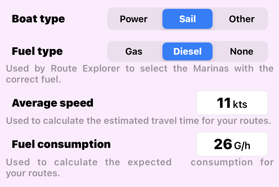
- Boat type: to set the type of boat you have. "Other" is intended for boat or other type of vehicle that does not fit with a "standard" power or sail boat.
- Fuel type: this information is used by the Route Explorer when searching for marinas with fuel. For the marinas that specify the type of fuel available, the Route Explorer will consider only those with the "right" type of fuel (so the one set here).
- Average speed: this information is used to calculate all the estimated time info related to the routes. You can set specific average speed for each route from the relative route settings page.
NOTE: this info is used for non active route, when you activate a route for navigation, then the current GPS speed is used. - Fuel consumption: This information is used to calculate the fuel consumption for the routes. You can set specific fuel consumption for each route from the relative route settings page.
Boat size
Here you can define the main boat dimensions.

- Draft: to set the max depth of the boat from the water level. This information is used to generate an alarm when receiving the depth info from a Wi-Fi connection.
- Height: to set the max height of the boat from the water level. This information is used by the Route Explorer to calculate the dangerous bridges.
NOTE: even if the Route Explorer uses some margins in addition to the value you enter, you shall remember that there are additional factors (eg tides, waves, wind, ...) that could change the real available height. - Beam: to set the width of the boat. This information is used by the Route Explorer to calculate the dangerous bridges.
- Length: to set the total length the boat. This information is currently not used for any calculation.
Contact info
These are the details to contact and identify your boat. This info will be shared with the Aqua Map community if you enable the Live Sharing functionality.
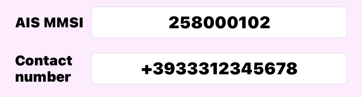
- AIS MMSI: this is your boat Maritime Mobile Service Identity number.
- Contact number: this is the telephone number to be contacted by other Aqua Map users.
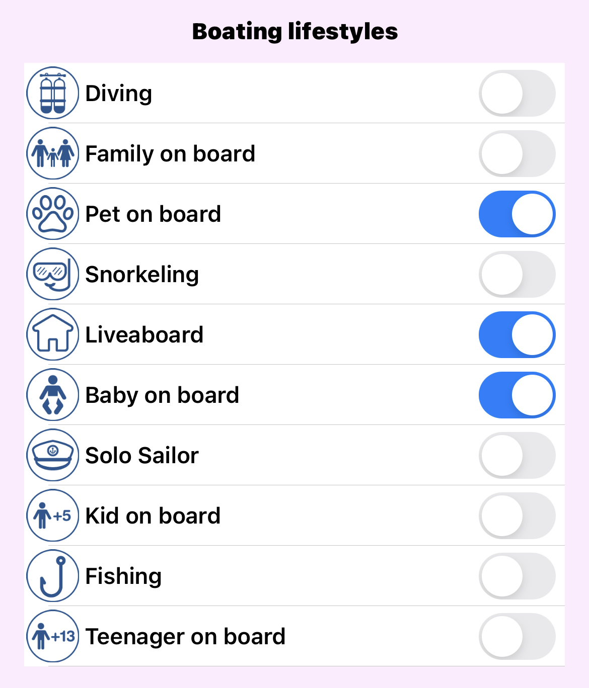
Boating lifestyles
The last group allows you to set your boating lifestyles.
This info will be shared with the Live Sharing community, allowing to search for users with common interests. You can select up to 3 boating lifestyles.